


Contamines Prarion

c.gourme
User
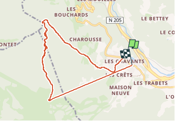

Length
9.5 km

Max alt
1953 m

Uphill gradient
937 m
Km-Effort
22 km

Min alt
1013 m

Downhill gradient
942 m
Boucle
No
Creation date :
2025-06-27 07:28:01.0
Updated on :
2025-06-27 13:21:29.031
4h45
Difficulty : Medium

FREE GPS app for hiking
 SityTrail
IGN / Geographical institutes
SityTrail Plus
The world is yours!
About
Trail Walking of 9.5 km to be discovered at Auvergne-Rhône-Alpes, Upper Savoy, Les Houches. This trail is proposed by c.gourme.
Description
Redescente par le télésiège de Prarion: 15,80€
Positioning
Country:
France
Region :
Auvergne-Rhône-Alpes
Department/Province :
Upper Savoy
Municipality :
Les Houches
Location:
Unknown
Start:(Dec)
Start:(UTM)
327788 ; 5085025 (32T) N.
Comments